History of the Illinois GIS Association
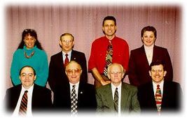
 Original Board: front row: Richard Hilton, Don Rich, Dick Dahlberg, Don McKay; back row: Sheryl Oliver, Jim Carter, Bob McLeese, Carol Zar.
Dr. Richard Dahlberg of the Geography Department at Northern Illinois University was key to the formation of ILGISA. This organization was built on the core of the Illinois Mapping Advisory Council (IMAC), which Dahlberg had headed since its inception. Early meetings of ILGISA were often held in conjunction with IMAC meetings and many IMAC members became members of ILGISA.
In 1991 the first GIS meeting was held in DeKalb. From 1991 to 1994, the Regional Development Institute at Northern Illinois University provided financial and logistical support for these GIS in Illinois conferences. Year by year the conferences grew in attendance, number of exhibits, and the variety and number of sessions.
Early in 1994 it became apparent that the annual conference had grown too large to be handled in the somewhat informal way we were following. A group of people who had been active in putting on the conferences met with the management and staff of the Regional Development Institute and agreed to take a more formal approach. Thus was born the Illinois GIS Association (ILGISA), incorporated as a not-for-profit professional association.
The Association has taken overall responsibility for the Annual Fall Conference, and created Regional Meetings which occur as many as 4 times a year throughout the state of Illinois. The association contracts with CM Services, the Association Partnership Company for conference and member support services.
The founding Board of Directors was established in August 1994 and was comprised of representatives from federal, state and local governments and universities with active GIS involvement in Illinois. The founding members and their roles were:
Carol Zar, of the Regional Development Institute, was the first Executive Director of ILGISA. She had experience with similar roles in other not-for-profit organizations and her perspective has been helpful to the ILGISA Board as it confronted many issues. Carol moved on in 1999 but still is called upon for advice. Mandy Davis was appointed the Executive Director in 1999. Sherrie Taylor assumed that title in 2001 when Mandy moved on to State government in Springfield. When ILGISA moved management companies in 2013, the Executive Director position was assumed by Rick Church of CM Services, Inc. Since then, Rick Church has moved to a Management Liaison position, and Megan Galeher has assumed the Executive Director role.
The creation of ILGISA established an independent voice for the diverse and ever-growing community of GIS users in the state. It represented an enhancement of the Illinois Spatial Data Infrastructure, and the organization continues to support other efforts at promoting the application of GIS to problem solving throughout Illinois, efforts such as formation of the Illinois Geographic Information Council (ILGIC).
ILGISA sponsored a fall and spring conference each year from 1995 - 2013. In 2014, ILGISA implemented a new schedule, shifting to one annual conference in the fall, and as many as 4 Regional Meetings across the state of Illinois throughout the year. An important component of ILGISA has been the cooperation and support of the private sector and many agencies at the municipal, country, regional, state and federal levels. Commercial vendors have worked with us to present a valuable showcase to our members, as well as sponsoring a reception for the pleasure of all.
Our publications have their own history. Dahlberg and his colleagues at NIU Laboratory for Cartography and Spatial Analysis had been publishing a journal of mapping activities in the State. Of particular help in this effort were Rich Vaupel, and Don Luman at NIU. First issued as Illinois Mapnotes in 1981, after ten years the title evolved into Illinois GIS and Mapnotes. This journal soon became the voice of ILGISA.
As ILGISA came into its own, it demanded a newsletter published more frequently than the annual journal. The first ILGISA Newsletter came into existence in July 1995.
Illinois GIS and Mapnotes continued to be published with the personal commitment of Dr. Dahlberg. The issues became larger and more costly. When Dahlberg passed on in 1996 the mantle to keep Mapnotes going was taken up by Dr. Don Luman, then at the Illinois State Geological Survey. Luman put together the last two issues of Illinois GIS and Mapnotes.
For many reasons ILGISA realized that it was not practical to continue to publish Mapnotes as the voice of the Association. In 2000 the first issue of Illinois GIS Notes was published. At first only two issues per year are to be published but with time the goal is to move to three or four issues per year.
Our web page was first housed at the University of Illinois at Chicago, thanks to the work of Board member Jim Bash. As the organization matured we realized the web presence needed a professional touch. We purchased the name 'www.ilgisa.org' and in 2001 set up a relationship with the manager of this site. In 2022, 'www.ilgisa.org' underwent a complete overhaul. The website you see today is a result of this redesign.
In 1991 the first GIS meeting was held in DeKalb. From 1991 to 1994, the Regional Development Institute at Northern Illinois University provided financial and logistical support for these GIS in Illinois conferences. Year by year the conferences grew in attendance, number of exhibits, and the variety and number of sessions.
Early in 1994 it became apparent that the annual conference had grown too large to be handled in the somewhat informal way we were following. A group of people who had been active in putting on the conferences met with the management and staff of the Regional Development Institute and agreed to take a more formal approach. Thus was born the Illinois GIS Association (ILGISA), incorporated as a not-for-profit professional association.
The Association has taken overall responsibility for the Annual Fall Conference, and created Regional Meetings which occur as many as 4 times a year throughout the state of Illinois. The association contracts with CM Services, the Association Partnership Company for conference and member support services.
The founding Board of Directors was established in August 1994 and was comprised of representatives from federal, state and local governments and universities with active GIS involvement in Illinois. The founding members and their roles were:
- Richard Dahlberg, President, Northern Illinois University
- Richard Hilton, Vice-President, County of Lake Department of Management Services
- E. Donald McKay, Treasurer, Illinois State Geological Survey
- Donald Rich, Secretary, Illinois Department of Transportation
- James Carter, Board Member, Illinois State University
- Robert McLeese, Board Member, USDA Natural Resource Conservation Service and Illinois State Soil Scientist
- Sheryl Oliver, Board Member, Illinois Department of Natural Resources
Carol Zar, of the Regional Development Institute, was the first Executive Director of ILGISA. She had experience with similar roles in other not-for-profit organizations and her perspective has been helpful to the ILGISA Board as it confronted many issues. Carol moved on in 1999 but still is called upon for advice. Mandy Davis was appointed the Executive Director in 1999. Sherrie Taylor assumed that title in 2001 when Mandy moved on to State government in Springfield. When ILGISA moved management companies in 2013, the Executive Director position was assumed by Rick Church of CM Services, Inc. Since then, Rick Church has moved to a Management Liaison position, and Megan Galeher has assumed the Executive Director role.
The creation of ILGISA established an independent voice for the diverse and ever-growing community of GIS users in the state. It represented an enhancement of the Illinois Spatial Data Infrastructure, and the organization continues to support other efforts at promoting the application of GIS to problem solving throughout Illinois, efforts such as formation of the Illinois Geographic Information Council (ILGIC).
ILGISA sponsored a fall and spring conference each year from 1995 - 2013. In 2014, ILGISA implemented a new schedule, shifting to one annual conference in the fall, and as many as 4 Regional Meetings across the state of Illinois throughout the year. An important component of ILGISA has been the cooperation and support of the private sector and many agencies at the municipal, country, regional, state and federal levels. Commercial vendors have worked with us to present a valuable showcase to our members, as well as sponsoring a reception for the pleasure of all.
Our publications have their own history. Dahlberg and his colleagues at NIU Laboratory for Cartography and Spatial Analysis had been publishing a journal of mapping activities in the State. Of particular help in this effort were Rich Vaupel, and Don Luman at NIU. First issued as Illinois Mapnotes in 1981, after ten years the title evolved into Illinois GIS and Mapnotes. This journal soon became the voice of ILGISA.
As ILGISA came into its own, it demanded a newsletter published more frequently than the annual journal. The first ILGISA Newsletter came into existence in July 1995.
Illinois GIS and Mapnotes continued to be published with the personal commitment of Dr. Dahlberg. The issues became larger and more costly. When Dahlberg passed on in 1996 the mantle to keep Mapnotes going was taken up by Dr. Don Luman, then at the Illinois State Geological Survey. Luman put together the last two issues of Illinois GIS and Mapnotes.
For many reasons ILGISA realized that it was not practical to continue to publish Mapnotes as the voice of the Association. In 2000 the first issue of Illinois GIS Notes was published. At first only two issues per year are to be published but with time the goal is to move to three or four issues per year.
Our web page was first housed at the University of Illinois at Chicago, thanks to the work of Board member Jim Bash. As the organization matured we realized the web presence needed a professional touch. We purchased the name 'www.ilgisa.org' and in 2001 set up a relationship with the manager of this site. In 2022, 'www.ilgisa.org' underwent a complete overhaul. The website you see today is a result of this redesign.


